| Tours | Unesco WHS | Guidebooks |
|---|---|---|
0 groups tours with set departures
|

0 World Heritage Sites | country, regions and cities |
| Time zone: | GMT +3 (Eastern Africa time) | Daylight savings: None |
|---|
| Main languages: | Arabic, French | Other languages: Comorian |
|---|
| Currency: |
Comoran francs (KMF) €1 = KMF491, $1 = KMF435, £1 = KMF579 (rates as of Sep 2016) |
|---|
| Internet Domain: | .km | International Dialling Code: 269 |
|---|
For help planning your trip to Comoros including visas, vaccinations, currency exchange, flights, accomodation and insurance, see our Comoros trip planning page.
Further information on Comoros
Discover more about Comoros - the country's geogrpahy and natural features, an assessment of its status on freedom and rights and data on the country's population and economy.
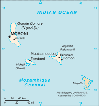
Geography & Natural Features
Total area: 2,170 sq km (0 sq km under water)
Coastline: 340 km (Mozambique Channel)
Neighbours (border lengths): No land borders
Climate: Tropical marine climate with rainy season between November and May with a risk of cyclones.
Highest mountain: Le Karthala (2,360m)
Freedom & Rights
Summary status and rankings for Comoros from classifications of different organisations measuring political and economic freedom, democracy and civil rights. See more details of these rankings.
| Index | Status | Rank | |
|---|---|---|---|
 | Freedom in the World | Partly Free | - |
 | Democracy Index | Authoritarian regime | 127/167 |
 | Economic Freedom | Mostly Unfree | 142/179 |
 | Press Freedom | Satisfactory situation | 49/179 |
 | ILGA LGBT rights | No rights | - |
 | Corruption Perceptions | High corruption | 142/174 |
| Overall Ranking: | 141/195 | ||
Other Data & Links
Full name: Union of the Comoros Status: Independent Country
Population: 766,865 (rank: 159/196) Density: 353.3 people/sq km (rank: 24/196)
Ethnic groups: Antalote, Cafre, Makoa, Oimatsaha, Sakalava
Religions: Sunni Muslim 98%, Roman Catholic 2%
GDP (PPP): $0.911 billion GDP per capita: $1,300 (rank: 177/195)
Information derived from the CIA World Factbook. Other country profiles: BBC News.


